
Machilipatnam is in Krishna district of Andhra Pradesh. There are evidenced of its existence since the 3rd century BCE mainly during Satavahana period when, according to Ptolemy, it was known as Maisolos. The Periplus of the Erythraean Sea also mentions it in the 1st century BCE.
Situated in the mouth of the River Krishna, the Masula port saw flourishing sea trade. Muslin clothes were traded by ancient Greeks from Masulipatam. Several Roman coins were found during excavations near Masulipatnam.
There were Arab merchants in the area at least since the 13th century. The Portuguese controlled between 1598 and 1610.
Masulipatam was the first British trading settlement in 1611 on the Bay of Bengal. From 1686 to 1759 the city was held by the French and Dutch, until it was finally ceded to the British, who captured the city and fort from the French in 1759.
(2) Madura / Madurai / Koodal / Thirualavai

Madurai is located on the bank of river Vaigai in Tamil Nadu. It was the capital of the Pandyas during the Sangam Age in early centuries of Christian era.
Sangam literature in Tamil was compiled in Madurai during three congregations of Tamil scholars in Madurai.
The city has been ruled, at different times, by the Early Pandyas, Medieval Cholas, Later Cholas, Later Pandyas, Madurai Sultanate, Vijayanagar Empire, Madurai Nayaks, Chanda Sahib, Carnatic kingdom, and the British.
The city has a number of historical monuments, with the Meenakshi Amman Temple and Tirumalai Nayak Palace being the most prominent.
Meenakshi Amman Temple, dedicated to Parvati (Meenakshi) and her consort Shiva (Sundareswara) was rebuilt by Madurai Nayakas. The temple is in Dravida Stye and is surrounded by gopurams (gateway tower). Each gopuram is a multi-storeyed structure, covered with thousands of stone figures of animals, gods and demons. The temple was sacked by Malik Kafur in 1310 and later rebuilt by Nayakas in 16th century. Few 17th and 18th century paintings of Nayaka period survives.
Madurai was an important trading centre mainly of cotton fabrics in the ancient times.
(3) Mahabalipuram / Mamallapuram / Mamallapattana

It is located in Tamilnadu. Mahabalipuram is a town in Kancheepuram district in the Tamil Nadu. It was largely developed by the Pallava King Narsimhavarman Mamalla in the 7th century AD.
It is famous for Pallava monuments. Temples here were built largely during the reigns of Narasimhavarman and his successor Rajasimhavarman and show the movement from rock cut architecture to structural building. The monuments are mostly rock cut and monolithic and constitute the early stages of Dravidian architecture. They are constituted by cave temples, monolithic rathas, sculpted reliefs and structural temples.
The Group of Monuments at Mahabalipuram has been classified as a UNESCO World Heritage Site.
Famous monuments are:
(a) Descent of the Ganges – a giant open-air rock relief
(b) Pancha Rathas (Five Chariots) – Of the nine monolithic temples found in Mahabalipuram, the most important are Five Rathas known after the famous five Pandava brothers of the Mahabharata fame. Each of these is carved from one single large piece of granite stone.
(c) Shore Temple, a structural temple along the Bay of Bengal with the entrance from the western side away from the sea.
Mamallapuram was a port city of the Pallavas. They used the port to launch trade and diplomatic missions to Sri Lanka and Southeast Asia. An 8th-century Tamil text written by Thirumangai Alvar described this place as Sea Mountain ‘where the ships rode at anchor bent to the point of breaking laden as they were with wealth, big trunked elephants and gems.
(4) Mahasthangarh

Silver punch marked coins (4th century BC–2nd century AD), uninscribed copper cast coins, Gupta period coins, vast number of shards, terracotta plaques etc are excavated. A 5th century Buddha stone sculpture, a Lokesvara stone sculpture showing blending of Visnu and Avalokitsvara, a number sand stone door-frames, pillars and lintels, numerous Buddha bronze sculpture(10th–11th century) etc are excavated.
(5) Mahadaha

- In Pratapgarh district, UP
- Human skeletal remains found: a Gangetic Mesolithic site
- The late Mesolithic period in India saw the emergence of agriculture in the Harappan civilization. From here agriculture spread east and south replacing hunting and gathering. Health throughout the world changed as agriculture was adopted, which can be seen in human skeletal remains. Langhnaj and Mahadaha are two of these late Mesolithic hunting and gathering sites. Langhnaj is located in western India within the area the Harappan civilization controlled and had access to domesticated food. Mahadaha is located in eastern India in an area with no evidence of agriculture.
(6) Mahagraha / Mahagara (Near Allahabad)
- In Allahabad district, Uttar Pradesh
- Neolithic site, evidence of cultivation of rice
- In the Eastern and Central Indian Neolithic scenario, domesticated rice and handmade pottery occurred at Koldihawa and Mahagara within the Neolithic levels (9000 BC)
(7) Mahisadal

- It is located in Birbhum district of West Bengal.
- Two fold cultural sequence :
- Period 1 (1600-1400 BC): Ceramics of black and red ware and painted red ware, some copper,beads of steatite and semi-precious stones,bone tools/bangles, terracotta gamesmen, comb
- Period 2 (750 BC): Iron objects and unburnt clay seal.
(8) Mahishmati / Maheshwar

It is situated on the bank of river Narmadain Madhya Pradesh. It was the southern capital of Avanti, a Mahajanapada of 6th century BC.
It was an important trading centre and famous for the cotton goods in ancient times. It was well connected with Rajgir and Paithan.
- It is an iron bearing megalithic site in Maharashtra in Vidarbha region along with Naikund.
- Burial site of megalithic period has been found. It was a large bead manufacturing center in ancient times.
- A clear evidence of technological advance in the form of hardening and quenching followed by tempering in addition to the knowledge of steeling as early as 900 BC.
(10) Majgaha

- It is an Iron bearing Megalithic site in Durg district of Chhattisgarh
- Other Megalithic sites nearby are Karakabhat, Chirchari, Dhanora and Sorar in Durg district of Chhattisgarh. A new megalithic site is explored at Bisrampur.
(11) Malkhed / Manyakhet

Manyakheta was the modern Malkhed is situated in Gulbarga district in Karnataka on the banks of Kagina River. It was founded by Rashtrakutas (whose founder was Dantidurga) and subsequently became the capital of Rashtrakutas in 9th and 10th century. The capital was moved to Manyakheta by Amoghavarsha.
Later it came under the control of Western Chalukyas.
It was a centre of Saivism and Vaisnavism.

It is situated in Western Madhya Pradesh. It was the important commercial centre and lay on the route from north to the Western Coast.
A stone inscription of the time of Kumara Gupta (437 AD) refers to the construction of a magnificent Sun Temple by a guild of silk-weavers who had immigrated feom southern Gujarat.
Two monolith pillars were erected here by King Yasodharman in 528 AD with inscription which describe his exploits including victory over the Huna Chief Mihirkula.
Hinglajgarh Fort is an ancient fort situated in Mandasor. This fort has been at its peak of grandeur during Parmara rule.
- On the right bank of Chenab river, west of Jammu. It is northernmost Indus valley Civilisation. It has pre-harappan and harappan settlement.

Mandla is situated in Mandla district of Madhya Pradesh.
According to the inscription in the palace of Ramnagar, the Gond-Rajput dynasty of Garha-Mandla commenced in the fifth century, with the accession of Jadho Rai, a Rajput adventurer who entered the service of an old Gond king, married his daughter, and succeeded him to the throne.
In 1564, during Mughal Emperor Akbar, Asaf Khan was the Mughal viceroy who invaded territories of Gond-Mandla. The queen Durgavati, then acting as regent for her infant son, met him near the fort of Singorgarh in Damoh District; but being defeated, she retired past Garha towards Mandla. Her valiant effort to save her kingdom is still subject of folklore.
Mandla Plant Fossils National Park is situated in Mandla district of Madhya Pradesh in India. This national park has plants in fossil form that existed in India between 40 million and 150 million years ago spread over several villages of Mandla District.
(15) Mandu


Mandu was a famous hill fort in the old Dhar state of central India. When Timur captured Delhi in 1401, the Afghan Dilawar Khan, governor of Malwa, set up his own kingdom and Ghuri dynasty was established and the golden age of Mandu began. Under his son Hoshang Shah, It became the capital of Malwa. Several monuments like Hindola Mahal were built during his reign. Hoshang Shah’s Tomb made in marble is refined example of Afghan architecture. Jami Masjid was also built.
Muhammad Khalji established the Khilji dynasty. He built the Jahaz Mahal for his Harem. In 1526, Mahmud who was the 6th Khalji ruler made no resistance against the invading Bahadur Shah of Gujarat who conquered Mandu in 1531. I 1534, Mandu came under Humayun’s rule who relaxed here for a brief period. Later he lost it to Khalji rulers.
Baz Bahadur was famour ruler due to his love for Rani Rupamati and his singing art. He was defeated by Akbar and joined his court. Mandu has architectures like Rani Rupmati Pavilion and Baz Bahadur’s Palace.
In 1625, Khurram in rebellion against his father Shahjahan took refuge in Mandu.
The fort of this place contains many mosques, palaces, tombs and dwelling places which are fine specimens of Afghan architecture.
(16) Maner
Maner is located in Patna district of Bihar. Maner is one of the chief spiritual centers in India. Maner Sharif has two very popular Muslim tombs: One of Makhdum Yahya Maneri, known as the Bari Dargah. Another of Makhdum Daulat, known as Chhoti Dargah. In Maner Sharif, Makhdum Daulat in 1608 breathed his last. It was then in 1616 that Ibrahim Khan, Governor of Bihar, who was also his disciple finished the construction of his mausoleum.
(17) Mansehra
- In Mansehra District, Khyber-Pakhtunkhwa province of Pakistan.
- The area of Mansehra has been under the rule of various emperors and governments, including Ashoka, the Afghans, the Turks and the British Empire.
- During the Maurya dynasty, Mansehra was a part of Taxila. The Edicts of Ashoka inscribed on three large boulders in Mansehra record fourteenth Ashokan edict, presenting aspects of the emperor’s dharma or righteous law. Dating to middle of the third century BC, they are written from right to left in the Kharosthi script.
(18) Mansura (Brahmanabad)
(19) Martand

- The Martand Sun Temple was a Kashmiri Hindu temple dedicated to Surya and built during the 8th century CE. Now in ruins, the temple is located five miles from Anantnag in Jammu and Kashmir.
- It was built by a King of the Karkota Dynasty, Lalitaditya Muktapida and was destroyed by Islamic ruler Sikandar Butshikan in the early 15th century CE.
- It was an excellent specimen of Kashmiri architecture, which had blended Gandharan, Gupta, Chinese, Roman, Syrian-Byzantine and Greek forms of architecture.Various wall carvings in the antechamber of the temple proper depict other gods, such as Vishnu, and river goddesses, such as Ganga and Yamuna, in addition to the sun-god Surya.
(20) Maski

It is situated in the Raichur district of Karnataka. Here, a minor rock edict of the Mauryan Emperor Ashoka has been discovered. It was the first edict of Emperor Ashoka that contained the name Ashoka in it instead of the earlier edicts that referred him as Devanampiye piyadasi.This edict was important to conclude that many edicts found earlier in the Indian sub-continent in the name of Devanampiye piyadasi, all belonged to Emperor Ashoka.
The excavations indicated that the region was occupied by Neolithic-Chalcolithic and Megalithic cultures.
(21) Mathura
It is situated on the bak of Yaunna in Agra district of UP. It was also kown as various other names like Madhupuri and Saurpura. It was a rich and prosperous city in the ancient time and was an important centre of Buddhism and Vaishnavism. The Mathura School of Arts developed here mainly under the patronage of the Kushanas.It was second capital of Kushanas apart from Purushpura.
In mythology, the place is attached with Lord Krishna.
(22) Meerut

(23) Mehargarh / Mahagriha

Mehrgarh is a Neolithic (7000-3200 BC) site on the Kachi plain of Baluchistan, Pakistan, and one of the earliest sites with evidence of farming (wheat and barley) and herding (cattle, sheep and goats) in Indian subcontinent.
They also had the techniques for fishing. It was famous for one of the earliest cultivation of cotton. Mehrgarh is supposedly the most sophisticated, ingenuous and best planned ancient farm villages of ancient India.
The most unique discovery is the known origin of the dental surgery and related medicinal activities exercised in Mehrgarh area.
Figurines of terracotta and clay have been found along with those of stone.
During the period 2500 BCE – 2000 BCE there has been a migration towards newly settled harappan sites.
|
(24) Mirzapur
 |
- Mirzapur was established by the British East India Company in 1735 while the civilization at here was found in 5000 BCE. As a proof of the existence of the lower Paleolithic age culture, the artifacts of prehistoric caves, the painted rocks and other evidences in the Belan River Valley. Here we can find the evidences that are more than 17000 BCE.
- Some interesting petroglyphs in the sandstone of the Vindhya range are found in Morhana Pahar in Mirzapur district. The depictions of chariots, horses, weapons and people in these works.
- It is the place in India where the Holy River Ganges meets with Vindhya Range. This is considered significant in Hindu Mythology
(25) Modhera

Modhera is located in Gujarat on the bank of the river Pushpavati. It is famous for the Sun Temple built in 1026 AD by King Bhimdev of the Solanki dynasty. Solankis were considered to be Suryavanshi, Gurjar or descendants of Sun god. Royalty and traders jointly contributed to build grand temples. The temple was so designed that the first rays of the sun fell on the image of Surya, the Sun God, at the time equinoxes.
The temple is partially in ruins after it was also finally destroyed by the Allauddin Khilji.
The Sun temple is of a unique architecture. The temple comprises three separate, axially aligned and integrated elements: Surya Kund, Sabha Mandap and Guda Mandap.
Sexual iconography is displayed, at the exterior walls of the main temple itself.

- Mohenjo-daro is an archeological site in the province of Sindh, Pakistan.
- Built around 2600 BCE, it was one of the largest settlements of the ancient Indus Valley Civilization, and one of the world’s earliest major urban settlements, contemporaneous with the civilizations of ancient Egypt, Mesopotamia, and Crete. Mohenjo-daro was abandoned in the 19th century BCE. It is designated a UNESCO World Heritage Site.
- Mohenjo-daro means Mound of the Dead in Sindhi.
- Cock-fighting may have had ritual and religious significance for the city, with domesticated chickens bred there for sacred purposes, rather than as a food source.
- The site occupies a central position between the Indus River and the Ghaggar-Hakra River. The Indus still flows to the east of the site, but the riverbed of the Ghaggar-Hakra on the western side is now dry.
Architecture and urban infrastructure:
- Mohenjo-daro has a planned layout based on a street grid of rectilinear buildings. Most were built of fired and mortared brick; some incorporated sun-dried mud-brick and wooden superstructures.
- The sheer size of the city, and its provision of public buildings and facilities, suggests a high level of social organization.
- The city is divided into two parts: (1)The Citadel (2) The Lower City.
- The Citadel is a mud-brick mound around 12 metres high – is known to have supported public baths, a large residential structure designed to house about 5,000 citizens, and two large assembly halls.
- The city had a central marketplace, with a large central well. Individual households or groups of households obtained their water from smaller wells. Waste water was channelled to covered drains that lined the major streets. Some houses, presumably those of more prestigious inhabitants, include rooms that appear to have been set aside for bathing, and one building had an underground furnace (hypocaust), possibly for heated bathing. Most houses had inner courtyards, with doors that opened onto side-lanes. Some buildings had two stories.
- One large building in Mohenjo-daro as a “Great Granary”. Certain wall-divisions in its massive wooden superstructure appeared to be grain storage-bays, complete with air-ducts to dry the grain. Carts would have brought grain from the countryside and unloaded them directly into the bays.
- Close to the “Great Granary” is a large and elaborate public bath(Great Bath).From a courtyard, steps lead down to the brick-built pool, which was waterproofed by a lining of bitumen. It may have been used for religious purification.
- “Pillared Hall”, thought to be an assembly hall and the “College Hall”, a complex of buildings comprising 78 rooms, thought to have been a priestly residence.
- Mohenjo-daro had no series of city walls, but was fortified with guard tower sites that there was some kind of political or administrative centrality, but the extent and functioning of an administrative center remains unclear.
- Seated and standing figures, copper and stone tools, carved seals, balance-scales and weights, gold and jasper jewellery, and children’s toys.
- Dancing Girl: A bronze statuette dubbed the “Dancing Girl”, with bangles, her hand on her hip. The statue led to two important discoveries about the civilization: first, that they knew metal blending, casting and other sophisticated methods of working with ore, and secondly that entertainment, especially dance, was part of the culture.
- Priest-King: A seated male soapstone figure was found. Though there is no evidence that priests or monarchs ruled Mohenjo-daro, it was called “Priest-King”.It depicts a bearded man with a fillet around his head, an armband, and a cloak decorated with trefoil patterns (double circle and single circle designs). The two ends of the fillet fall along the back. The hair is carefully combed towards the back of the head. Two holes beneath the highly stylized ears suggest that a necklace or other head ornament was attached to the sculpture.
- Pashupati seal: A seal bears the image of a seated, cross-legged figure surrounded by animals. The figure has been interpreted by some scholars as a yogi, and by others as a three-headed “proto-Shiva” as “Lord of Animals”.
- Seven-stranded necklace: The necklace has an S-shaped clasp with seven strands, each over 4ft long, of bronze-metal bead-like nuggets connecting each arm of the “S” in filigree. Each bead is less than the size of a pepper-seed and has many facets.
(27) Monghyr

(28) Mukhalingam
It is located in the Srikakulam district of Andhra Pradesh. It is identified with the capital of the Eastern Ganges and it is famous for the Madhukeshhvara temple which follows the early Odisan art tradition. The discovery of sherds of the Rouletted ware of Roman type and a Satavahana coin from the site of Mukhalingam indicates its commercial importance and trading activities in the early Christian era.
(29) Multan
Multan is located in Pakistan. It was situated on a very strategic place in the north-west India. It was conquered by Arabs led by Muhamad Bin Qasim in 712 AD. In 11th century, Mahmud of Ghazni destroyed looted the city and destroyed the famous Sun Temple which is mentioned by Al Beruni. Later it was also attacked and destroyed by Muammah Ghuri. After the establishment of Delhi Sultanate, it became part of the Sultanate.
It came under the Mughals and after their decline, Marathas and then Sikhs invaded and occupied Multan.
Multan is famous for Sufi shrines.
(30) Mundigak (Near Kandhar)
(31) Muradabad
(32) Murshidabad
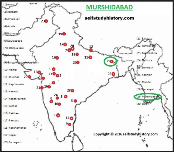
It is situated in West Bengal. In 1704, Murshid Quli Khan, the Diwan of Bengal under Aurangzeb transferred the capital of Bengal from Dacca, and renamed the city Murshidabad after his own name. In 1716, he attained the title of Nawab of the Subah (province) of Bengal, and Murshidabad became his capital.
In 1742, Marathas under the Bhonsle of Berar plundered Murshidabad and got booty.
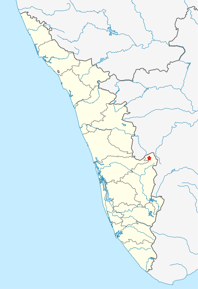
(33) Muziris

It is in modern Cranganore on the western coast of Kerala. It was a flourishing ancient port in the early Christian centuries (Sangam Age).
It carried trade with Arabia, Rome, Greece etc.
Samgam literature, Greek & Roman writers like Pliny mention Muziris.
Commodities exported from Muziris were spices, semi-precious stones, pearls, diamonds, sapphires, ivory, tortoise shells etc. The Romans brought money (in gold coins), figured linens, sulfide of antimony, copper, tin, lead, coral, raw glass, wine etc.
Though the Roman trade declined from the 5th century AD, the former Muziris attracted the attention of other nationalities, particularly the Chinese and the Arabs.
(34) Marayur / Marayoor:
- Marayur or Marayoor is a town in Idukki district of Kerala, India.
- Also called Muniyaras, megalithic dolmens belong to the Iron Age. These dolmenoids were burial chambers made of four stones placed on edge and covered by a fifth stone called the cap stone.
- Ancient rock paintings are part of Marayur heritage at Attala, Ezhuthu Guha (literally means “cave of writing”), Kovilkadavu and Manala in Marayur panchayat.
(35) Mysore

- The Mahishuru Fort was constructed in 1524 by Chamaraja Wodeyar III (1513–1553).
- The Mysore Kingdom, governed by the Wodeyar family, initially served as a vassal state of the Vijayanagara Empire. With the decline of the Vijayanagara Empire after the Battle of Talikota in 1565, the Mysore Kingdom gradually achieved independence, and by the time of King Narasaraja Wodeyar (1637) it had become a sovereign state. Seringapatam (modern-day Srirangapatna), near Mysore, was the capital of the kingdom from 1610.
- The kingdom reached the height of its military power and dominion in the latter half of the 18th century under the de facto rulers Hyder Ali and his son Tipu Sultan.


Kindly clarify how to match grid lines with MAP which is given by UPSC in Exam. At what degree you have drawn grid lines.
Waiting for your reply